Can a topographic device fit into your pocket?The choice of the professionals!


Your mobile Topographer!
The leading tool for the professional surveyor or anyone who wants to mark his property, offering the best accuracy and extensive functionality that no other app can!
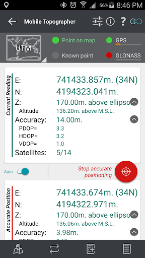
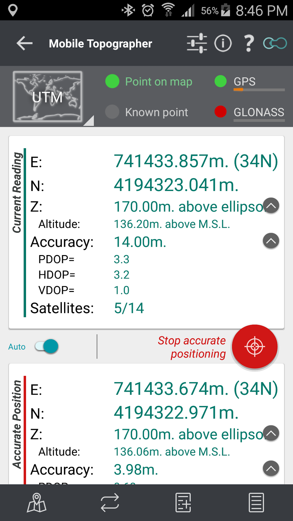
*** Increase GPS accuracy using:
- Weighted averaging (on every axis).
- Map calibration.
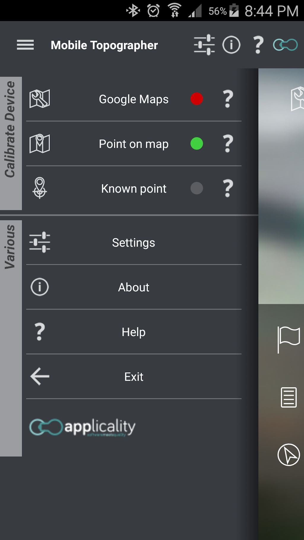
- Device calibration on map, or on a know point.
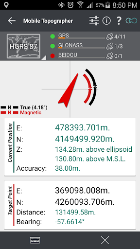
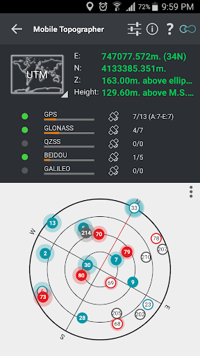
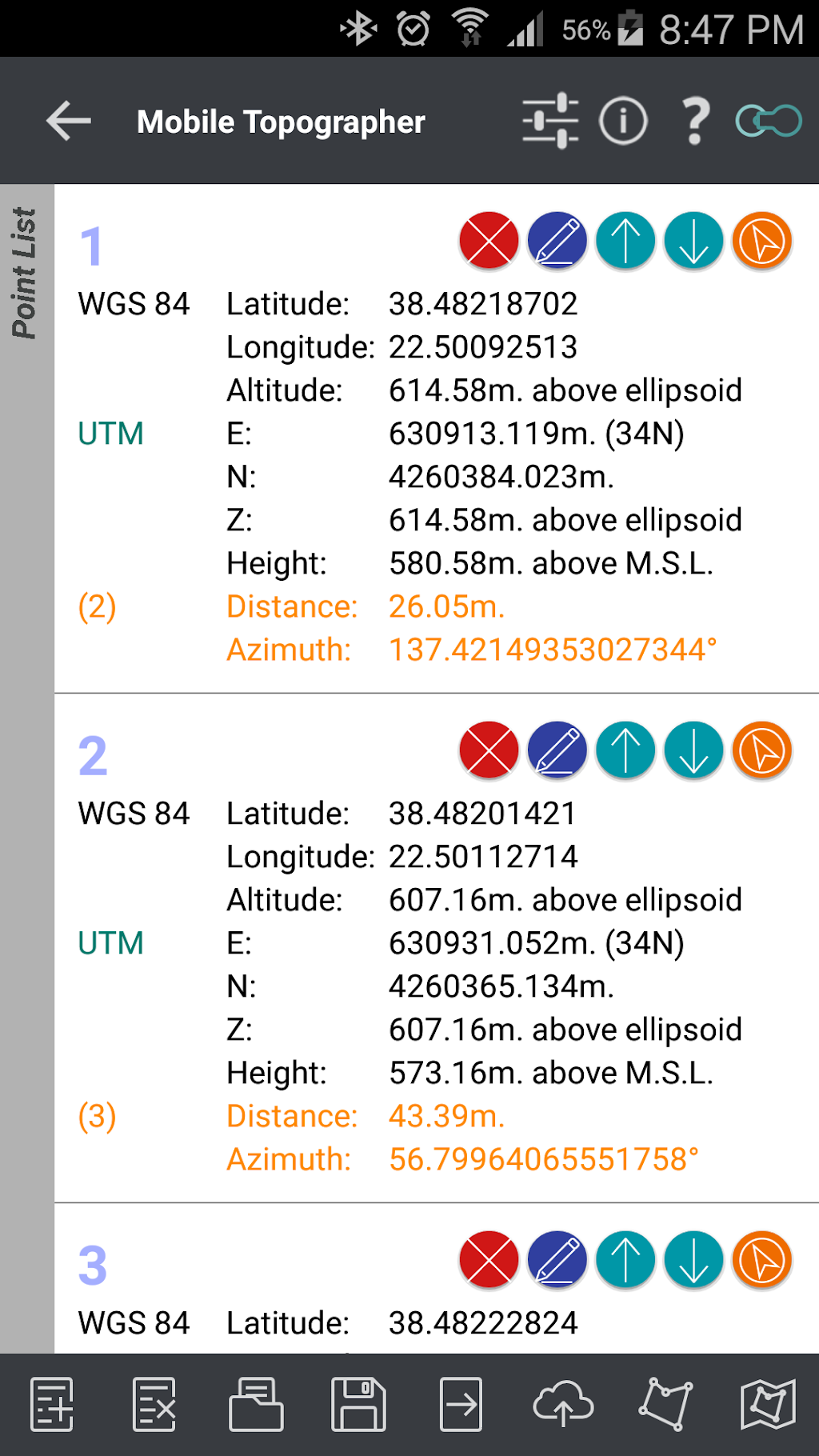
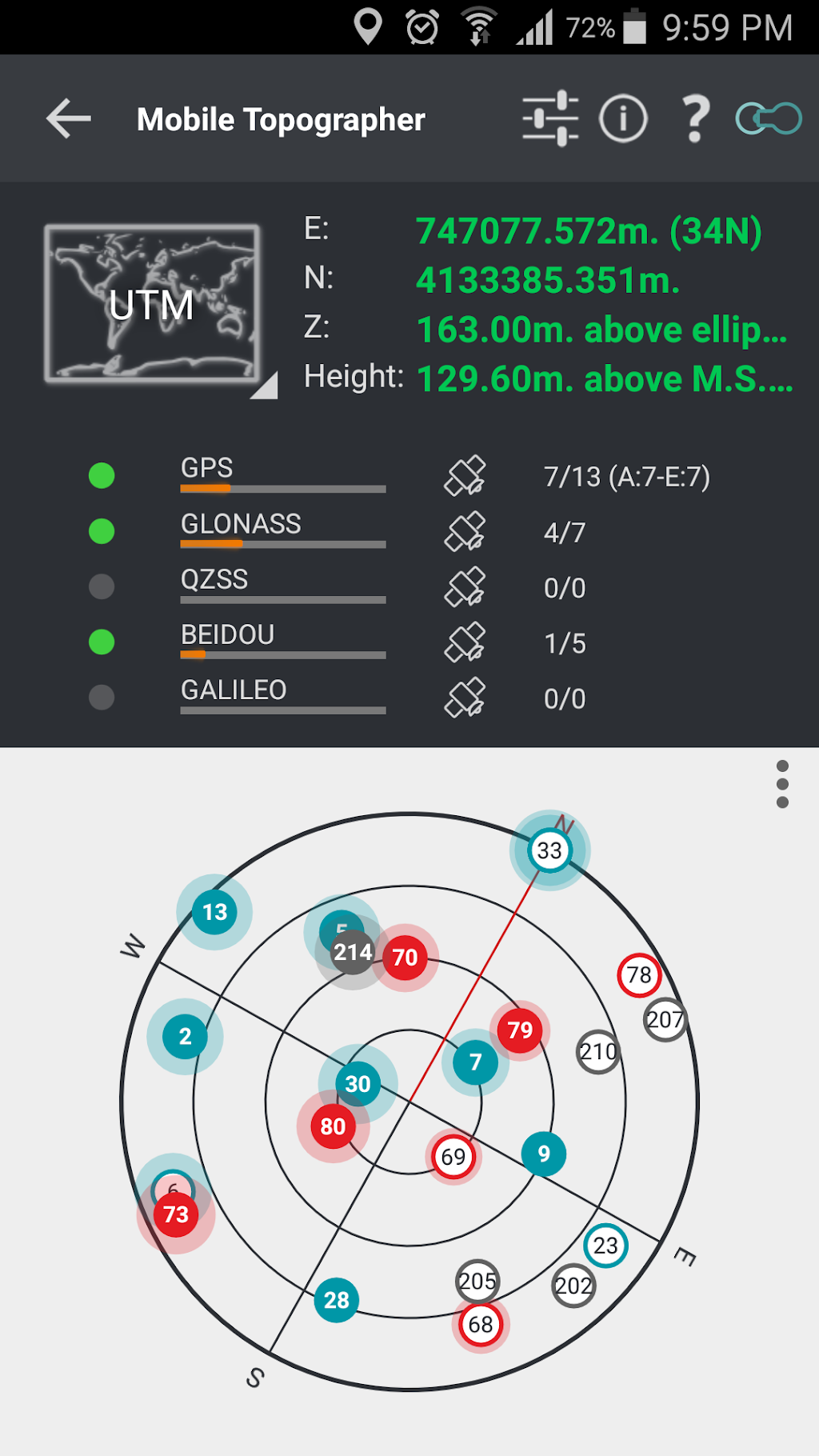
*** Display and convert GPS geodetic to Cartesian EN coordinates and back:
- UTM.
- Europe ETRS89/UTMZ28-38.
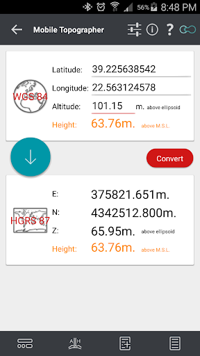
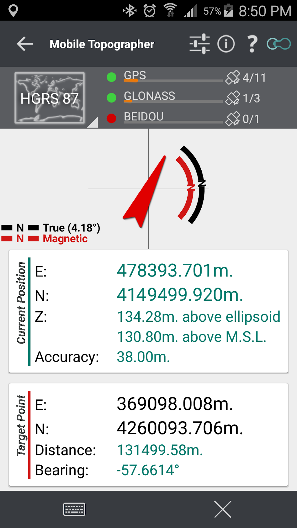
- Hellas HGRS 87 (EGSA 87).
- Hellas HGRS 87 - HEPOS.
- Hellas HTRS07/TM07.
- Iceland ISN93/Lambert 93.
- Morocco Merchich.
- SPCS83 (124 zones) USA.
- Romania S-42(58)/Stereo 70.
- Lebanon & Syria Deir ez Zor/Stereo.
- Croatia HTRS96/TM.
- Serbia SRB-ETRS89/UTM, SRB-MGI/Z7.
- Australia MGA94 (GDA94), AMG66 (AGD66) National, A.C.T., Northern Territory, NSW & Victoria, Tasmania,AMG84 (AGD84).
- Former FR of Yugoslavia MGI Balkans zones 5,6 & 7.
- Italy Monte Mario West Zone 1 Peninsular, West Zone 1 Sardinia, East Zone 2 Peninsular, East Zone 2 Sicily.
- Costa Rica CΜ05/CRTM05, Ocotepeque 1935 Costa Rica Norte & Ocotepeque 1935 Costa Rica Sur.
- Cyprus CGRS-93-LTM.
- Hungary HD72/EOV.
- Kosovo KosovaREF01.
- Latvia LKS92/TM.
- Lithuania LKS94/TM.
- Spain ED50/UTMZ29-30 NW, ED50/UTMZ29-31 ML & ED50/UTMZ31 BA.
- Uk's OSTN02/OSGM02.
- Turkey ED50/Gauss-Kruger 3° Z9-15, ITRF96 & ED50/UTMZ35-38.
- Luxembourg LUREF.
- Venezuala REGVEN/Z18-20.
- Sweden SWEREF99 TM.
- Argentina POSGAR 94 & POSGAR 2007.
- India Kalianpur 1975 ZI - ZIV.
- Algeria Nord Sahara 1959 / Z29-32.
- Armenia, Georgia, Azerbaijan, Estonia, Latvia, Lithuania, Russia - Kaliningrad and Kazakhstan Pulkovo 1942/ CS63 (A)Z1-4, (C)Z0-2, (K)Z2-4.
- Central and South America SIRGAS 2000.
- Nigeria and Cameroon Minna 1996 & 2008 MTM West, Mid, East Belts & UTM Z31-33.
- Bangladesh Gulshan 303/TM.
- France RGF93/CC42-50.
- Canada CSRS
- Egypt 1907 Blue, Red, Purple, Extended Purple belts.
- Portugal ETRS89/PTM06.
- Netherlands Amersfoort/RD new.
- Qatar QND95.
- Colombia MAGNA-SIRGAS Far West, West, Bogota, Central East, East zones.
- Mexico ITRF 2008/LCC.
- Madagascar Tananariva (Paris)/Laborde & Tananariva/UTM Z38-39S .
- Tunisia Carthage (Paris)/Mining Grid, Carthage/Nord, Carthage/Sud, Carthage/TM 11 NE, Carthage/UTM zone 32N.
- Liechtenstein CH1903/LV03C-G.
- Switzerland CH1903/LV03 (old), CH1903+/LV95 (new).
- Brazil SAD69/UTM Z18-25 & SAD69(96)/UTM Z18-25
- Spain Canary Islands REGCAN95/LAEA & REGCAN95/LCC & REGCAN95/UTM Z27-28
*** Auto stop for accurate positioning.
*** Examine the satellites above you in a sky view.
*** Signal strength and number of satellites indication for each GNSS constellation individually.
*** Multiple units support:
- Meters,
- International feet,
- US survey feet.
***Height calculation:
- Ellipsoidal height.
- EGM96 orthometric height calculation.
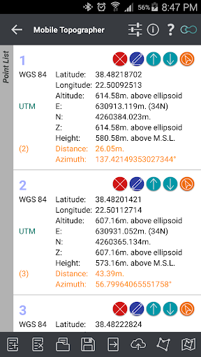
*** Convert from geodetic to Cartesian coordinates and back:
- Support for device measured points, or
- Manually input of geodetic or Cartesian coords.
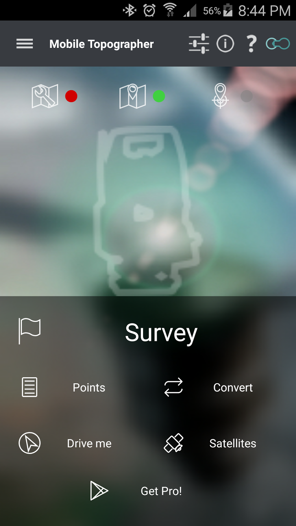
*** Drive me:
- Key in coordinates of the target point in either geodetic or Cartesian coordinates, or select a point from the list and follow the pointer.
- Compass indicating both magnetic and true North.
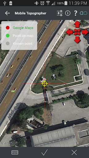
*** Project on Map:
- Project individual points on any map application.
- Project list of points, and the defined polygon, on embedded maps.
*** Save multiple point lists, to use them later.
*** Calculate area.
*** Export point lists το:
- .txt (text file)
- .csv (point file - comma separated)
- .kml (google earth file)
- .gpx (Gps Exchange format)
- .dxf (drawing file)
*** Send file via e-mail, or upload it to cloud.
*** Complete help text support.
Help us improve Mobile Topographer by e-mailing your comments and suggestions.
TAGS: Survey Surveyor Property GPS GNSS GLONASS QZSS BEIDOU GALILEO